Поиск книг, учебников, пособий в онлайн-магазинах
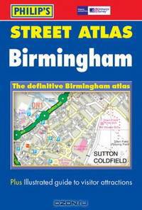
Street Atlas Birmingham
издатель: "Philip's", ISBN: 0540083771, 978-0540084326This atlas shows every named road, street and lane in Birmingham, with visitor attractions clearly marked, and one-way streets, pedestrian areas and through-routes all highlighted. Schools, colleges, hospitals, police stations, post offices, car parks, sports centres and local government offices are all featured. Two pages of "Navigator" mapping give an overview, with all major and minor roads. The coverage of the whole Unitary Authority is at 2 1/4 miles to an inch, with ultra-large coverage of the centre at 1 mile to 7 inches.
| В наличии: | ||||
|
|
OZON.ru - 180 руб. |
Перейти 
|
||
Рейтинг книги:  5 из 5, 8 голос(-ов).
5 из 5, 8 голос(-ов).
Популярные книги по минимальной цене:
 50 руб.
|
 50 руб.
|
 100 руб.
|
 234 руб.
|